


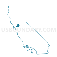
Voting District 10035, Solano County, California
About
Outline

Summary
| Unique Area Identifier | 544481 |
| Name | Voting District 10035 |
| County | Solano County |
| State | California |
| Area (square miles) | 14.86 |
| Land Area (square miles) | 10.00 |
| Water Area (square miles) | 4.86 |
| % of Land Area | 67.29 |
| % of Water Area | 32.71 |
| Latitude of the Internal Point | 38.12214600 |
| Longtitude of the Internal Point | -122.30472810 |
Maps


Graphs
Select a template below for downloading or customizing gragh for Voting District 10035, Solano County, California


Neighbors
Neighoring Voting District (by Name) Neighboring Voting District on the Map
- Voting District 10005, Solano County, CA
- Voting District 10036, Solano County, CA
- Voting District 10050, Napa County, CA
- Voting District 10455, Sonoma County, CA
- Voting District 20065, Solano County, CA
- Voting District 20066, Solano County, CA
- Voting District 50485, Napa County, CA
Top 10 Neighboring County Subdivision (by Population) Neighboring County Subdivision on the Map
- Vallejo CCD, Solano County, CA (144,838)
- Napa CCD, Napa County, CA (115,175)
- Sonoma CCD, Sonoma County, CA (40,608)
Top 10 Neighboring Place (by Population) Neighboring Place on the Map
Top 10 Neighboring Elementary School District (by Population) Neighboring Elementary School District on the Map
Top 10 Neighboring Secondary School District (by Population) Neighboring Secondary School District on the Map
Top 10 Neighboring Unified School District (by Population) Neighboring Unified School District on the Map
- Vallejo City Unified School District, CA (119,022)
- Napa Valley Unified School District, CA (115,531)
Top 10 Neighboring State Legislative District Lower Chamber (by Population) Neighboring State Legislative District Lower Chamber on the Map
Top 10 Neighboring State Legislative District Upper Chamber (by Population) Neighboring State Legislative District Upper Chamber on the Map
Top 10 Neighboring 111th Congressional District (by Population) Neighboring 111th Congressional District on the Map
- Congressional District 1, CA (704,012)
- Congressional District 6, CA (664,468)
- Congressional District 7, CA (655,708)
Top 10 Neighboring Census Tract (by Population) Neighboring Census Tract on the Map
- Census Tract 2518.03, Solano County, CA (4,988)
- Census Tract 2508.01, Solano County, CA (3,917)
- Census Tract 2518.04, Solano County, CA (3,655)
- Census Tract 2517.01, Solano County, CA (3,372)
- Census Tract 2517.02, Solano County, CA (2,578)
- Census Tract 2518.02, Solano County, CA (2,538)
- Census Tract 2010.05, Napa County, CA (2,418)
- Census Tract 1501, Sonoma County, CA (2,322)
- Census Tract 2011.02, Napa County, CA (2,055)